Many questions have been asked about why there was no Tornado Warning or warning sirens before the tornado hit Benton County.
The answer is far more complex than you might imagine. In this blog post, I’ll try to explain the reasoning of the decision makers and the evolution of the storms that occurred on Saturday, Oct. 13, 2012.
Supercell Tornadoes vs Squall Line Tornadoes
There is a fundamental difference in the structure of the storm that affected Benton County last night when compared to the storms of April & May which produce mile-wide monsters. The difference is the individual thunderstorm cell itself. More simply, supercell tornadoes are isolated cells and squall-line tornadoes occur in a line of several cells.
Below, I’ll try to explain the processes involved in the atmosphere. Keep in mind, the exact physics and dynamics involved in the creation of a tornado or “tornadogenisis” are still being studied and not completely understood by scientists.
The Supercell Tornado

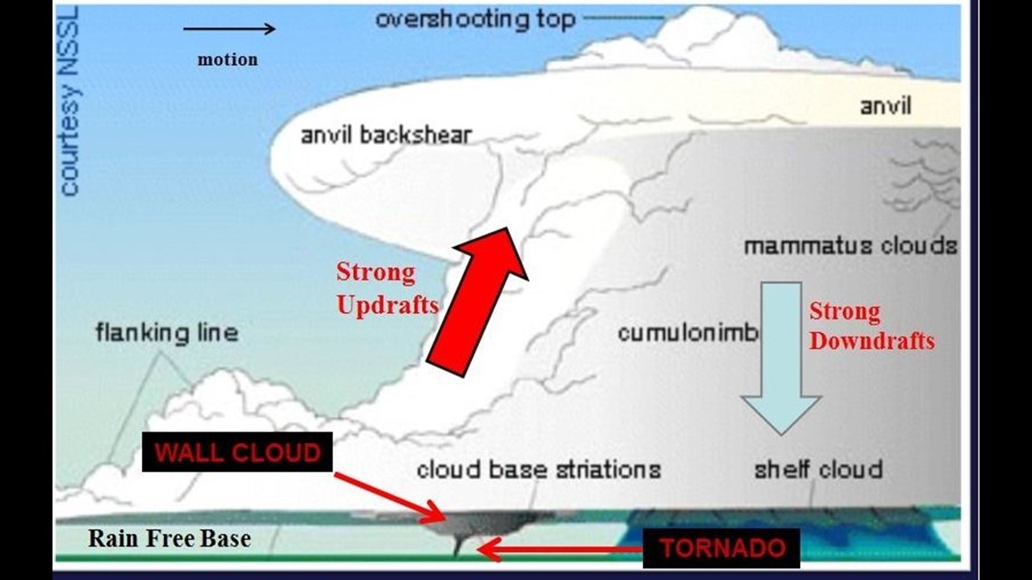
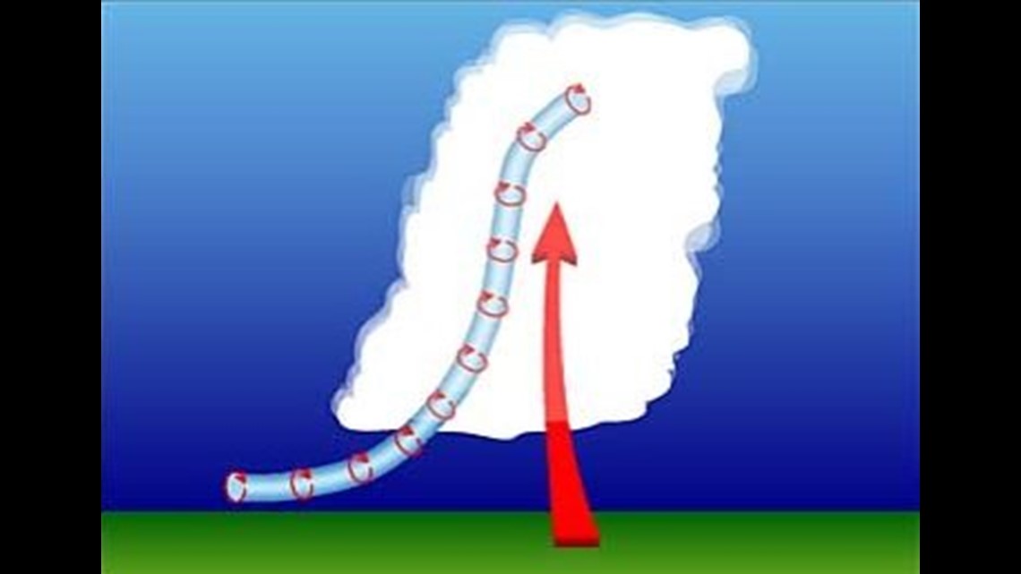
Supercell tornadoes occur from thunderstorms with deep rotation in the storm; rotation meteorologists refer to as a mesocyclone. This rotating column of air extends miles up into the atmosphere and is a result of changing wind speed and direction with height (shear) and the buoyancy of a warm airmass wanting to climb into a colder airmass due to density difference (instability).
The rising air will ingest some of the horizontal spinning towards the surface caused by different winds with heights (helicity). Think of an empty paper towel roll lying flat and rotating on the floor. If a storm with high instability develops it pulls the paper towel roll up by one end and the tube goes vertical. Laws of physics takeover such as “The Conservation of Angular Momentum” and the tube spins faster and faster much like an ice skater pulling their arms in while spinning. A tornado is potentially formed at the bottom of the updraft.


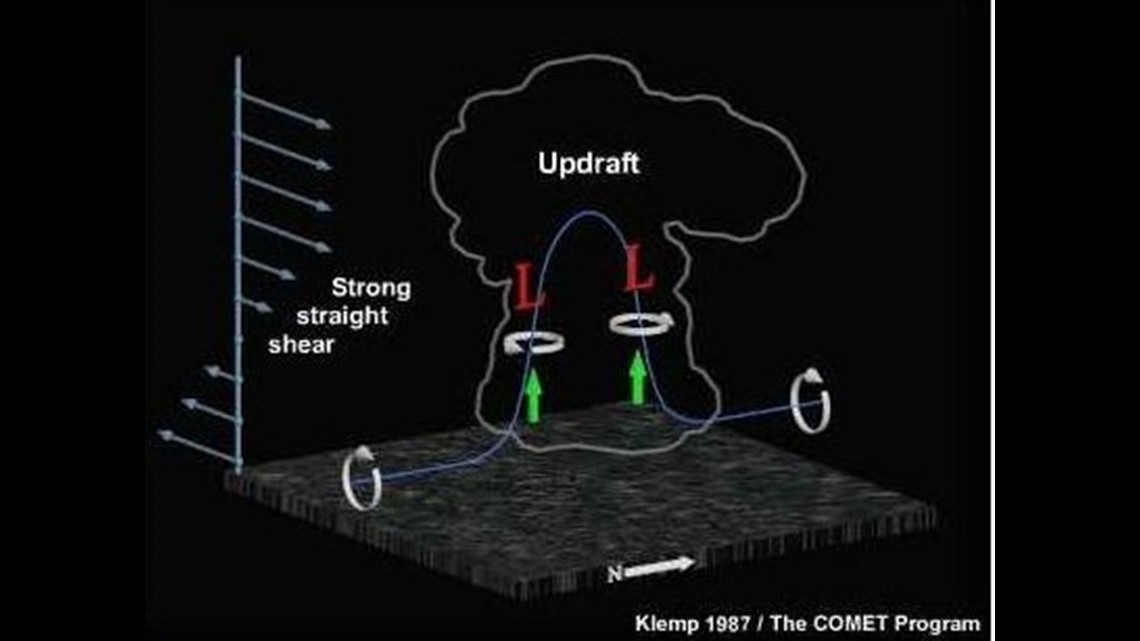
It’s the supercell tornado that causes the widespread EF5, mile-wide twisters with winds over 250mph. These storms are massive and they modify the environment so much they can live for hours. They only die which when the warm air rising… stops rising. This can be due to several factors, cold air being sucked in, water loading in the updraft, or moving into an environment with lower shear and instability.
The supercell tornado is easily seen on radar and nearly always has a tornado warning issued in association with it. The tornado that hit Denning was a supercell tornado. The Alabama outbreak of 2011 featured several supercell tornadoes. The Joplin tornado was a massive supercell tornado. We see these storms coming from miles away and the rotation is deep and persistent. The National Weather Service will always issue warnings on these.
The Squall-Line Tornado
Squall-line tornadoes are much different in their evolution. Squall lines occur along the leading edge of a cold front. The cold front literally lifts the warm air ahead of it to the level needed for it to rise (Level of Free Convection) Because the forcing is so strong along the leading edge of a cold front several cells form. A line develops and produces rain that cools the air and sinks. This sinking air is called a cold pool and can actually race ahead of the cold front causing new storms and updrafts. Storms in a line often have

the strongest winds on the leading edge of the line with precipitation extending behind the line for several miles. Storms with precipitation behind the line are called “trailing stratiform” and indicate the presence of strong winds in the atmosphere. When the direction of the wind shear is perpendicular (a right angle) to the line of storms… the storms are strongest and most severe. Most severe weather occurs in the initiation phase of squall lines.
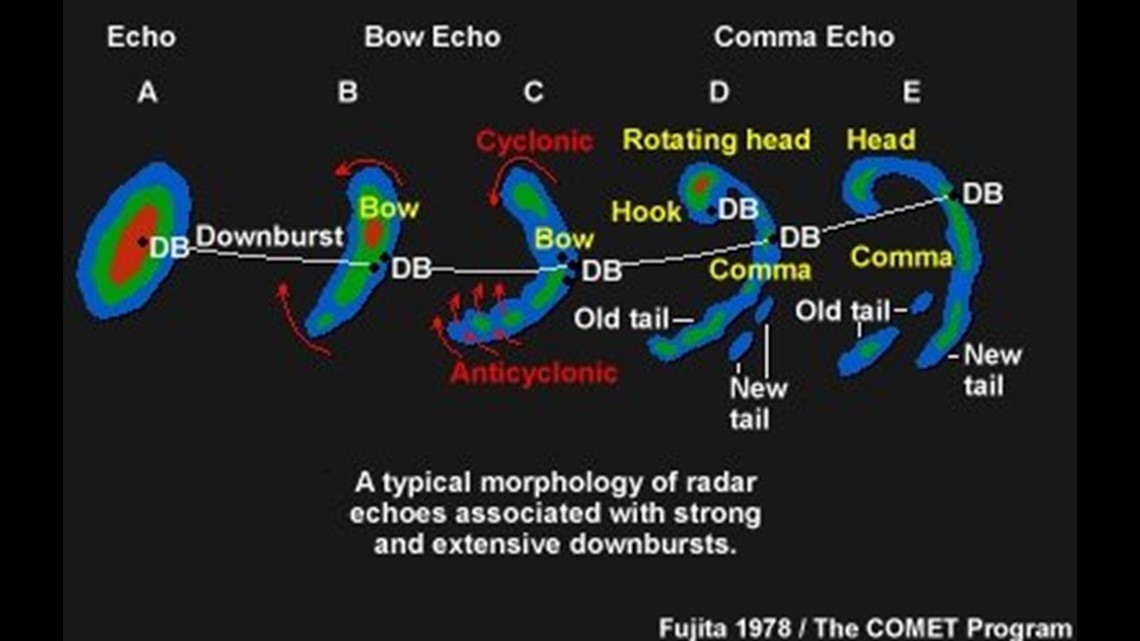
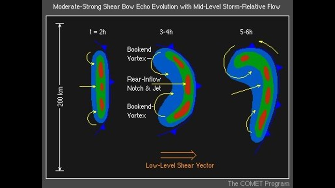
What happens next in squall lines is fascinating… As winds rush out of the line a “bow” forms. It looks like a big arc or banana on radar. Two important things begin to take place. As air mass and water vapor is evacuated behind the bow as well as on the leading edge of the updraft… low pressure is created. You can’t leave an empty space in the atmosphere. Air comes in to fill the empty space. In high shear, it comes from the drier air aloft. Much like you get cool out of the shower from the evaporative cooling… the dry air accelerates the cold pool and forces even stronger cells and damaging winds near the surface. This is called the “Rear Inflow Jet.”
The second important thing that occurs is the Coriolis Force caused by the spinning of the Earth. Coriolis enhances the northern circulation and creates broad rotation which can occasionally produce tornadoes. We refer to these as a “bookend vortex” or “spin up tornado” because they don’t occur in the same way as supercell tornadoes. They usually do not have a mesoscylone. Big tornadoes start with the mesocyclone in the middle of the atmosphere and work their way towards the surface. Squall-line tornadoes start near the ground and work their way up. Often occurring before any rotation rises up to the height of the radar beam.

Squall line tornadoes are usually short lived and are not as strong as supercell tornadoes. Typically by the time the warning is issued… the tornado is already gone.
The Squall Line Tornado Warning Dilemma
Squall line tornadoes are called QLCS Tornadoes in the meteorological world which stands for “Quasi Linear Convective System.” A debate continues within NOAA on how to handle QLCS tornadoes because they have such a high false alarm rate. It may surprise you, but on the night of the Benton County storm I was watching at least 6 other areas of rotation generated by bow echos. You would be surprised at how many storms with rotation that never produce tornadoes. I would say the vast majority never do. If all rotating storms were “tornado warned” we’d be under tornado warnings non-stop.
On Saturday, most of these areas of rotation did nothing although we believe another tornado did likely occur SW of Booneville about 4 miles south Washburn, AR. QLCS tornadoes are responsible for large false alarm rate. So much so, that social scientists discovered after the Alabama outbreak that people stopped taking tornado warnings seriously when the big supercell tornadoes strike. The NWS and NOAA have been under pressure to get their false alarm rate down.
An experiment was carried out last spring to enhance the wording on the tornado warnings to try and communicate “how bad” a tornado would be. This was not a success. A tiered tornado warning system has also been suggested. In my opinion, perhaps a new category of tornado warnings called “QLCS Tornado Warning” might be better but would be incredibly confusing to the general public.
On Saturday, we recognized the high risk of squall-line tornadoes due to the high amounts of shear yet relatively low instability. Sometime after 9 p.m. I conferenced with my news director and decided to preempt all programming on both KFSM and KXNW to cover the storms as they moved in. This is not something we typically do for squall lines, but the risk of QLCS tornadoes and wind damage was higher than most other squall lines due to high wind shear. In hindsight, it was a good decision.
Currently, there is no solution to the QLCS Tornado within NOAA other than to issue warnings based on the same criteria as the supercell tornado. The truth is, not all tornadoes are created equal and unfortunately it puts the National Weather Service offices such as ours in Tulsa & Little Rock in a poor situation: caught between over-warning on storms which will most likely not produce a tornado or not warning on storms that do produce a tornado.
You may be surprised to know during severe weather all media meteorologists as well as National Weather Service Meteorologists are in a closed, private chat session online discussing the situation. NWS was considering a tornado warning for the Benton County storm but elected not to. Although I can’t speak for them, I believe it was because there was not strong rotation on radar (the tornado occurred below the beam) and the new Dual Polarization Radar which detects debris from tornadoes showed only rain and no “non-meteorological targets”.
At the end of the day, the answer to “Why wasn’t there a tornado warning?” is as simple as there was no reason to believe a tornado was actually occurring.
-Garrett
(Note: Images above were taken from NSSL, NOAA, & Comet MetEd Training Modules)