While the spring tornado season is usually referenced as “Tornado Season” tornadoes are all too common in the fall and winter months as well. In fact, in the southeast United States more tornadoes occur in the fall months than in the Spring. Especially across Mississippi and Alabama in an area referred to as ‘Dixie Alley’.
In our area, the peak of tornado season is the 3rd week of April but the deadliest tornado to hit locations like Fort Smith actually occurred in the month of January. Winter tornadoes are not uncommon. The “Super Tuesday Outbreak” in February of 2008 produced the longest tornado track on record in Arkansas; a violent EF4 tornado which started just east of our location in Atkins, AR.
So what does a winter tornado outbreak look like? And how is different from spring?
The jet stream exists in the upper levels of the atmosphere as the warm air swells vertically and cold air contracts. A force is called the Pressure Gradient Force is created as the winds try to compensate for the heating difference. The winds are deflected due to the spin of the Earth known as the Coriolis Force and creates currents of air about 8 miles above the Earth moving around 100-150mph. The thermal differences are more distinct in the winter months because very cold arctic air is closer to very warm Gulf of Mexico air so the jet stream winds are usually stronger than in the Spring or Summer. This is why winter tornadoes often move faster than late spring tornadoes.
So what happened in our area to cause two tornadoes?
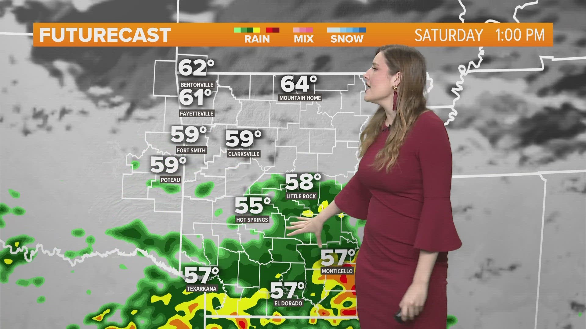
This week an area of low pressure caused strong warm, moist air to move northward into Arkansas. Temperatures were near record levels in the mid to low 70s. As a bend in the jet stream moved over the low pressure it evacuated mass in the upper levels causing the surface winds to converge creating rising motion. For severe storms you need three things: 1) Moisture 2) Instability 3) Lift. For tornadoes you also need: Shear. Shear is a change in wind speed and direction with height.
As the low continued to pull up warm, moist air from the Gulf… the jet stream brought in colder air above our heads; this warm air is less dense than cold air so it rises. This is called instability. When the low pressure pulled the cold front into the area we experienced lift. The cold air was literally “lifting” the warm moist air into the atmosphere where it accelerated in the vertical.
The first supercell thunderstorm that reached the tornado potential started in Sallisaw. This thunderstorm was able to ingest the low-level shear and stretched it vertically. The rising air in the updraft stretched the column of air more creating a mesocyclone (meso=middle cyclone=spin, literally a spin in the middle of the atmosphere). As the storm interacted with the jet stream winds, the upward acceleration increased and “like an ice skater pulling in their arms” the spin also increased due to the ‘conservation of angular momentum’ and a tornado was created 13 miles NE of Muldrow near Nicut at 2:55pm.
The supercell storm with a tornado in contact with the ground travelled for 7 miles and was as wide as 5 football fields at 525 yards with winds reaching EF2 intensity of 111-130mph. The tornado lifted 3 miles north of Natural Dam at 3:04pm.
I’ve ordered the radar data from the NCDC, a branch of the NOAA which archives radar products, to review the storm and I’ll share the data with you in a future blog post when the additional information becomes available.
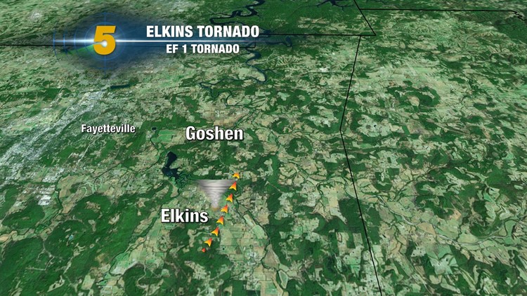
It appears that the initial circulation from the tornado in Natural Dam continued with a mesocyclone as it travelled north. The circulation was not strong in the low levels of the atmosphere but at some point the storm encountered a high pocket of wind shear and instability and generated another tornado 2 miles west of Elkins at 3:32pm and lifted at 3:39pm and was on the ground for around 4 miles. The width of the tornado is still being evaluated but the preliminary rating of the tornado was EF1 with winds of 86-110mph.
The same storm system that moved across our area caused numerous tornadoes across the deep south, including a tornado fatality which ended a streak of 220 days without a death from tornadoes.
-Garrett