LIVE BLOG: Winter Weather, Feb. 20-21
NOAA Image
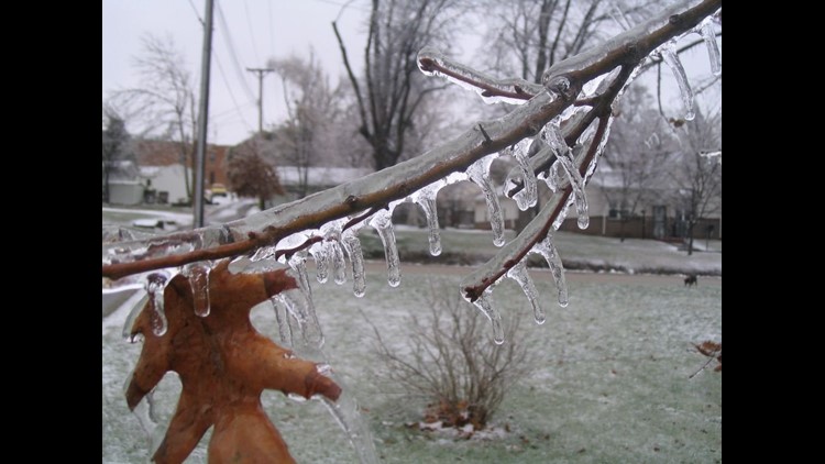
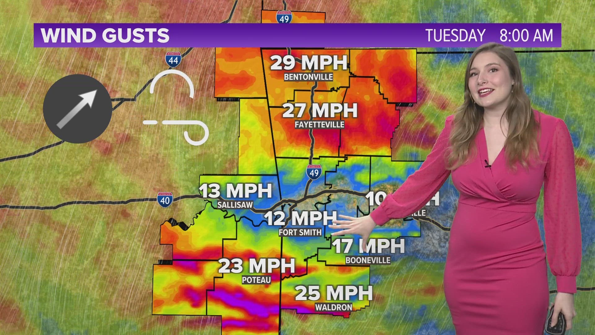
Winter weather with snow and freezing rain is expected to develop and move across Northwest Arkansas and the River Valley on Wednesday and Thursday. Snow and ice accumulations are possible. Power outages and travel disruptions could also occur. This live blog will be updated during the event with 5NEWS Meteorologists as the event unfolds with the latest information.
Ozarks Electric is reporting 37 power outages in its coverage area: 35 in Oklahoma, 2 in Arkansas.

This person rolled down their window in Booneville and the ice stayed put!
AROUND THE CLOCK: trucks are loaded with sand/salt at our Leigh Ave. site along I-540 in Ft. Smith.

Due to the inclement weather & concern for students & employees, NWACC will be closed today, February 21st, at all locations.
Normal schedule and no bus route changes today for the following districts: West Fork, Farmington, Gravette and Prairie Grove.
A car driven by a student hits a school bus at 5th and A in Bentonville. It was a minor accident with no injuries, police say.
Ozarks Electric is reporting 123 power outages in its Oklahoma and Northwest Arkansas coverage area.
Carroll Electric is reporting 7 power outages at its Cannich substation west of Bella Vista.
@5NEWSChristine
Heavy rain has picked up again here in Fayetteville.
Arkansas State Police are working an accident on I-540 in Bentonville. A white Ford Explorer collided with a black Cadillac. It appears no one was hurt. Traffic was backed up while troopers cleared the crash.

@NWSLittleRock
Spotter class scheduled for Booneville this evening has been postponed to March 28th. #arwx
Next wave moving in now. A mixture of freezing rain/sleet/rain and thunder. Heavy freezing rain now in Logan and Scott county. Temps right around freezing but icing could continue on trees and power lines making more power outages possible with gusty winds.
The school bus accident happened at 5th and A Street in Bentonville this morning. No injuries.
A car driven by a student hit a Bentonville school bus this morning near the high school according to officials. No word yet on injuries.
BREAKING Car driven by student hits school bus in Bentonville, Superintendent Michael Poore says. More details to come.
Arkansas State Police River Valley: Two Accidents on I-40 in Franklin County
Arkansas State Police NWA: Working several accidents on 540 Northbound
Several Accidents
Fayetteville Police:Fence Blew Down on Maple and West
Large Tree Limb Fell Down on Township and Old Wire
Both Now cleared.
Bentonville High School officials are shuffling classes around after part of the campus lost power this morning. http://on.5newsonline.com/sCGfhjB
@5NEWSChristine: Just spoke with Washington County dispatch. They are not working any accidents right now.

@5NEWSChristine: Rain is picking up here in Fayetteville. Allow extra time as you head out the door this morning.
Hundreds of people are also waking up without power Thursday morning.
Arkansas Valley Electric reports more than 333 are without power in Logan County, 101 in Crawford County, 26 in Scott County, 17 in Franklin County and 15 in Sebastian County.
SWEPCO reports 107 customers without power in Sebastian County.
RFD is responding to another accident on I-540 at Exit 83. It is reported as southbound with a single vehicle.
Bentonville Schools confirms parts of the high school are without power
Officials report two people injured in rollover accident on I-540 near exit 83 in Rogers

@5NEWSChristine
Traffic on/near I-540 in Fayetteville is moving smoothly right now.
I-540 north backed up one lane around exit 83 in Rogers.. Two cars on side of the road. Ambulance, fire, ASP on scene
Winter weather is impacting some local blood drives. The following blood drives have been postponed or cancelled for Thursday:
- Ozark Community Hospital, Gravette, Ark.
- Career Academy of Hair Design, Rogers, Ark.
@OGandE
About 6700 w/o power throughout OK. Crews working but conditions poor. Not sure how long it will be to restore.
RFD is responding to a traffic accident at I-540 and New Hope Road (Exit 83). It is reported as northbound.
Power outages reported north of Huntington

Driving around the Sooner state? This map has you covered.
Click the link for updated version:
Some power outage north of Muldrow, Roland and Liberty areas, a viewer reports
Thundering, high winds with freezing rain in Rudy. Hwy 282 is ice covered in spots, according to a viewer
Greenwood City Offices will be open this morning
Text listing of driving conditions courtesy Ark Hwy Dept http://www.arkansashighways.com/road/text.htm

@5NEWSChristine
Here’s a look at south Fayetteville. Roads are wet. Bridges and overpasses could be slick
Arkansas Valley Electric reporting power outages in Subiaco, Ozark
Mercy Clinic for Women in Fort Smith will be closed. All other Mercy Clinics in Fort Smith and Van Buren will open at 1 p.m.
Carroll electric reporting 88 power outages in Benton County
Traveling in Oklahoma, Arkansas or Missouri?
Check these maps and add these numbers to your cell phone before you hit the road: http://on.5newsonline.com/cmMIjNm
Grocery section of a Rogers Walmart experiencing power outages
@woodsallison
Ozark electric crews repairing down power line in Siloam Springs
Ark. State Police in NWA reporting some accidents early Thursday morning:
jack-knifed semi at 540/61mm in Fayetteville, no injuries
Mini van hit the bridge on hwy 72E, east of Bentonville at Sugar Creek, no injuries
Reports of several vehicles slid off the road on I-540 in front of Olive Garden at Exit 83 in Rogers
The 188th Fighter Wing has implemented the Inclement Weather Policy for the morning of Thursday, Feb. 21. If you have questions, please contact your supervisor.
@5NEWSChristine
Hard cold rain and sleet is really coming down in south Fayetteville. We are seeing lightning and even hearing thunder.
@5NEWSJoe
Starting to get reports of power outages north of Muldrow, with thunder and heavy freezing rain with flicking power in Winslow.
Thursday, Feb. 21 School Closings
Get them here: http://on.5newsonline.com/KXzPHiE

Numbers & Links for Road Conditions http://on.5newsonline.com/cmMIjNm
Intense band of freezing rain with thunder and lightning moving into NWA and parts of the River Valley. Rapid accumulation of ice with this band. Ice accumulations of a quarter inch and hour possible. Gusty winds will combine to create some power outages.

How freezing rain develops…
http://5newsonline.com/2013/02/20/garretts-blog-how-freezing-rain-develops/
University of Arkansas-Fort Smith has cancelled classes on Thursday
River Valley acts as a funnel with east winds, although temperature hasn’t changed much the dewpoint is down to 28 degrees. With a temp around 34 that should allso the airmass to cool to around 31 later tonight
Rain now falling in Fort Smith, this indicates to us that the warm layer is starting to make it’s way into the area and will favor the freezing rain potential tomorrow morning
3 students sustain non-life-threatening injuries when their school bus rolled over just outside of Russellville
All state troopers in Northwest Arkansas occupied working car crashes, according to Arkansas State Police. No serious highway or interstate crashes yet, police said.
Winter Storm Warnings for Benton, Washington, Crawford, Sebastian and Sequoyah counties to remain in effect until noon Thursday, according to the National Weather Service
LeFlore County Emergency Management:
Numerous roads throughout the county are becoming slick and dangerous.
Sebastian County and Sequoyah County, Okla., now included in counties under Winter Storm Warning
Heavy bands of snow continue to move snow across the River Valley region and will move northward this evening
The Arkansas Tech Ozark campus and its offices closed today at 2:45 p.m.
The fundraiser at Zaxby’s tonight to benefit the Fayetteville High School boys and girls basketball teams has been canceled.
A person has been hospitalized with non-life-threatening injuries following a crash near the intersection of Township St. and College Ave. in Fayetteville
Localized heavy band of snow moving across River Valley next 1-3 hours resulting in additional snowfall
Extremely heavy burst of snow has developed in N Leflore Co… tracking towards FSM
Below is a list of phone numbers and web sites to check for road conditions in Arkansas and Oklahoma.
Arkansas (http://www.arkansashighways.com/Roads/roads.aspx):
(501) 569-2374
(800) 245-1672
Oklahoma (http://www.dps.state.ok.us/cgi-bin/weathermap.cgi):
(405) 425-2385
(888) 425-2385
Another round of heavy snow about to move into the River Valley
The NorthWest Arkansas Community College campus in Bentonville closes at 6 p.m., but the Jones Center, Washington County Center and Farmington High campus all closed at 1:30 p.m.
Bentonville schools likely to remain open for the remainder of the school day, a school official tells Larry Henry
No plans for Rogers Public Schools to close early today due to weather
Ozark Regional Transit suspending services today at 2:30 p.m. because of severe weather
Springdale police have responded to 8 crashes since 10:30 a.m.. No one injured in any Springdale or Fayetteville wrecks so far
Fayetteville and Springdale police both dealing with lots of car crashes today. Fayetteville police have responded to 32 crashes since 10 a.m.
Typical Fayetteville snow/ice shift includes 16 to 20 workers. Fayetteville has expanded that today to about 25 workers
Crews have not started plowing in Fayetteville because of the lack of snow accumulation. Roads are mostly wet and full of sleet
Fayetteville road crews out with expanded staff, laying down a liquid solution and sand/ice mixture, city transportation officials say
The Junior hIgh regional basketball tournament scheduled for tonight in Fort Smith has been postponed.
Springdale elementary and middle schools are closing at 2 p.m., while junior and high schools are closing at 3 p.m.
Snow is melting off main roads, secondary roads are the problem this afternoon. Soil temps are in the low 40s air temps around 30, with lots of traffic…. temperatures that warm will melt snow, and although it looks bad, it’s not as bad as you would think if you slow it down a bit.
Road conditions are expected to improve this afternoon. Best thing to do is stay put until the heaviest snow moves out.
The second round later tonight will be more significant. This one is the weak one
The University of Arkansas closes at 2 p.m., spokesman says.
The Fayetteville Public Library is closed.
Classes are canceled at the Arkansas Tech Ozark campus, but the campus and offices are open.
There is some concern that the snow that fell this afternoon could drop temperatures down a few more degrees which could mean more widespread ice accumulations
Shiloh Christian is closing at 1:30 p.m.
Shiloh Christian bus to Pinnacle Hills is leaving Springdale at 1 p.m.
Haas Hall Academy in Fayetteville has closed. The school requests parents pick up their students as soon as possible.
The New School in Fayetteville is “strongly” recommending parents pick up their students are soon as possible.
Huntsville and St. Paul schools are closing at noon today.
Prairie Grove Public Schools are closing at noon today.
Greenland School District closes at 12:30 p.m.
Gentry Public Schools will close early today at 1 p.m.
The Fayetteville Public Schools will close early today (Wednesday, February 20) due to the winter weather. Here is the closing schedule (to accommodate the bus routes):
1:30 Middle Schools
1:40 Elementary Schools
2:10 Jr. High Schools
2:25 Sr. High Schools
@5NEWSDirector: VIDEO: Heavy snow in Fayetteville. http://t.co/mPrN8NSC
Gravette School District is rolling buses early: 2 p.m. (elementary, middle), 2:15 p.m. (high school).
Springdale Public Schools has no plans to roll buses early as of now. Here are the regular bus times: 3 p.m. (elementary), 3:15 p.m. (middle), 4 p.m. (high school).
@5NEWSLarry: The University of Arkansas has no plans to cancel classes in Fayetteville for the rest of the day today, spokesman says.
University Of Arkansas in Fort Smith is closed Wednesday.
Early Wednesday School Closings http://on.5newsonline.com/QY8ojuk
Snow is starting to accumulate on I-540 in Northwest Arkansas.
BRUSHY SCHOOLS ARE CLOSED FOR WEDS.
Pocola, OK schools will also close at noon.
LINCOLN PUBLIC SCHOOLS ARE CLOSING EARLY.
Fort Smith down to 33, Van Buren down to 34, Heavy snow falling. Airmass is nearing saturation so temps should stop falling at 31 or 32 and actually start increasing this afternoon.
Slush expected on roads
Facebook post from Entergy Arkansas: We have increased our additional linemen request to 1,000. We are also now asking for an additional 500 tree trimmers. Our storm team will seek all possible sources to make this happen. Right now, we are confirmed to have 300 additional linemen in state Wednesday evening.
Currently, all roads are fine. There is a little slush in S Scott Co
Still snowing in Fort Smith and River Valley area, surface temp is 37. Accumulation limited to grass. Could change back to all rain later today
The placement of the “Winter Storm Warning” vs. “Ice Storm Warning” reflects the difference in thinking from the National Weather Service in Tulsa and the NWS in Little Rock.
Truth is… just about anywhere in our area has the potential to pick up .25″ of ice or more. But right now the higher elevations of the Ozarks and Ouachitas are more likely.
Everyone is monitoring temperatures and the cold air to see how the temp changes with the ongoing rain/snow.
There is also some questions about the depth of the “warm layer” above us. Too warm and the precip will drag down some warmth and it will be all rain. Not warm enough and we see more snow than forecast. Just warm enough and everyone sees ice.
Forecasting winter weather is one of the most difficult and complicated things to forecast for meteorologists. We’re monitoring temps and trends hour by hour and adjusting the forecast with each set of new data.
If you live in the River Valley, pay close attention to the forecast today. If the east wind continues… it could cause temperatures to be a degrees or two lower which would bring the threat of ice farther south than current forecast reflects.

Right now the heaviest band of snow is moving through Southeast Oklahoma into the Ouachitas. Not out of the question to see a quick dusting of snow with this band as it moves north.

Still some dry air to contend with over eastern and NE Oklahoma. The rain/sleet/snow mix over SE Oklahoma is start to add some moisture to the air….this will help more winter mix fall there throughout the morning hours.

Snow starting to fall with round 1 of winter weather across SE OK and the Ouahitas. Here is a look at snow covering the ground in Mena.

A WINTER STORM WARNING has been issued for NWA (in red) and an ICE STORM WARNING has been issued for portions of the River Valley and the Ouachitas.
WINTER WEATHER ADVISORY Has been expanded for all areas north of I40. Expect to see a round of snow/rain mid-morning on Wednesday before the snow changes back to all rain Wednesday Afternoon. Still expecting the ice accumulations late Wednesday into Thursday morning
Due to inclement weather and concern for students and employees, NorthWest Arkansas Community College will be closed today at all locations.