It only takes a few minutes outside to know we’re in the spring storm season. Warm, humid air has surged across much of the south with widespread rains in the forecast tonight and Wednesday (April 10).
The risk of severe weather is minimal due to a strong capping inversion aloft and the shallow Arctic nature of the cold front out west. Despite incredible surface heating the risk of a tornado outbreak does not exist. Typically, the first severe risk of the spring season generates plenty of talk and hype but there are several factors which favor a rain/temperature plunge type of event as opposed to a full-blown severe weather episode.
Here’s what’s working for… and against… severe storm development:
Our main concern has been a lone or isolated supercell developing ahead of the cold front. Although that looks unlikely given the current environment, the strong surface heating could force a storm or two through the warmer capping inversion giving way to a severe supercell and tornado risk.
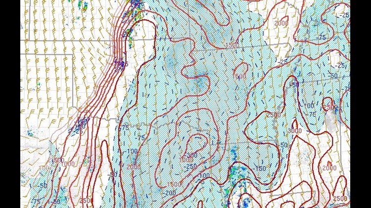
The capping inversion is a layer of warmer air above our heads. Today, it’s located around 7,400ft. If you go outside and look at the cumulus clouds you’ll see their tops are leveled off at this inversion. If surface heating is warm enough, sometimes it can push through the inversion with supercells and tornadoes developing. If this occurs today in our area it would be the exception but it would cause a rapid tornado risk. The upper level winds do not favor long track tornadoes. Essentially, if a storm developed, the colder air produced by the rain and the evaporation would cause the updraft to be choked off fast. The window for a supercell and tornado is rather small. Not 0%, but very limited.
The second negating factor for severe storms is the shallow nature of the Arctic airmass which will actually cause freezing rain in central Oklahoma tonight. The shallow cold air will be sucked into the updraft of thunderstorms creating storms that eventually transition from a surface-based tornado threat to an elevated-based hail/wind theat. In fact, hail is quickly becoming the most likely severe risk with this event. Probably in the neighborhood of quarter to half-dollar with the strongest storms. The timing would be late tonight and towards morning.
Regardless, there’s plenty of heat and moisture across our area and there will be plenty of thunderstorms across the entire region overnight and into Wednesday morning. Wednesday looks like a rainy, chilly day with temperatures falling into the 50s and lows in the upcoming nights in the 30s. Rainfall totals will be around an inch or more and rain may not clear the area until around 5 or 6pm on Wednesday.
Plan on dressing the kids back in the jackets and jeans again on Wednesday and even Thursday morning. The warmer trend will take place into the weekend, but it looks like yet another chance for rain could move into the picture on Saturday.
Garrett