The first significant round of winter weather could affect our area later on this week. Cold, shallow, dense air will move in from the Arctic on Wednesday night and settle into the area for several days with highs slipping into the 20s and 30s area wide.
Enough moisture is in place for freezing rain, sleet, & snow as early as Thursday before changing to all snow on Friday. The upper low finally moves across the area on Sunday providing yet another chance for snow accumulations.
Here is a look at our current thoughts, as well as some of the questions and uncertainty regarding the upcoming winter weather:
- When does it start? Currently appears to be sometime Thursday with a rain changing to freezing rain, then to sleet, then to snow. Should be all snow by Friday.
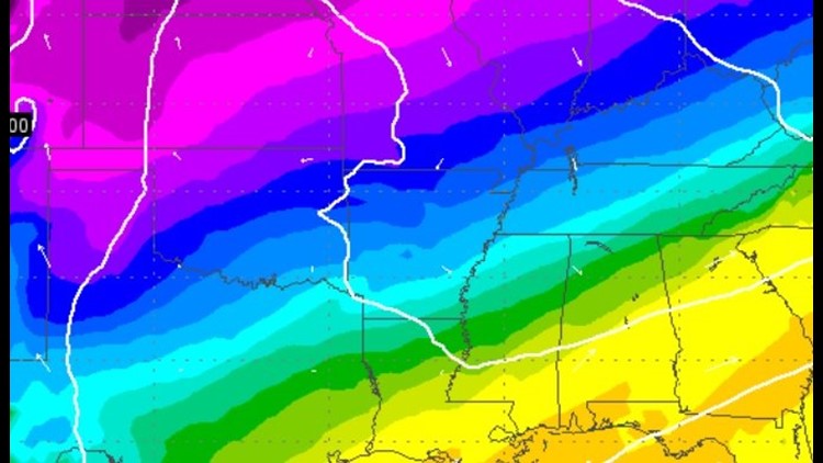
- How much accumulation? Since all precip types will be possible it’s too early to know how much of ‘what’ will fall. More as snow? More as ice? More as sleet? The amounts will become clearer once we see how shallow the cold air is… super shallow means more rain and ice because there will be more warm air aloft. Very deep cold air will be all snow. This will not be known with a high degree of certainty until sometime on Wednesday or Wednesday night when the cold air mass is sampled by the upper air balloon soundings across the country and then integrated into the computer simulations. It does appear we have around .50″ to work with which will be divided up between the different types of precip.
- What are my initial thoughts? I’m thinking we see all three precip types which will probably cause an ice layer to develop on the surface with some light snow accumulation on top. In my experience, road departments usually don’t pretreat the roads when rain is forecast to change to snow because it washes it off. Usually the road problems are more extensive with this scenario. Temperatures in the mid 20s mean most bridges and overpasses will be slick.
- Will school be cancelled? Each district has different criteria and is evaluated by superintendents. For the kids emailing whether or not they should study for their finals: Yes, do your homework. Our school closings automatically populate online and we’ll have them for you instantly on ‘5NEWS This Morning’ should closings occur.
- Is it over Friday? No. There will be another round of snow Sunday into Monday. Looks like it would be more of a snow instead of freezing rain though because the cold air will be much deeper by then. The Thu/Fri event should, however; be over by 5pm Friday.
- Should I cancel_____? I would wait to make decisions on events and travel until Wednesday when the forecast becomes more understood. My wife is scheduled to go out-of-town Friday. I told her to wait until Wednesday to cancel.
- Is this mainly a NWA winter event? No. Cold air should be in place area wide as far south as Texarkana and eventually Mississippi. I do, however think RV sees more ice/sleet/rain and NWA sees more snow because it’s farther north and the airmass is deeper.
- Can I drive? Because road conditions vary from location to location and are affected by vehicle type and skill level it will be different for each person. We’ll have LIVE reports should the road conditions be affected to help you make the best decision possible for you and your family where you live.
More updates coming on the weather blog tomorrow with a better look at some of the meteorological data that will be new in the next 24 hours. Meteorologist Joe Pennington will have updates first thing in the morning and new HD Futurecast Data arrives just before the 10pm each night. By Wednesday, we should be able to have a better defined area of what could happen.
One thing is for certain. It looks extremely cold for everyone all weekend and into next week with highs only in the 20s and lows possibly in the single digits in some locations.
-Garrett