It’s already surpassed them in one way, central pressure — which essentially weighs the air above a system that’s a key measure of any storm’s strength.
The early Friday central pressure recording of 880 millibars (the barometric pressure equivalent is 25.98 inches) “is the lowest for any tropical cyclone globally for over 30 years,” according to the Met Office, Britain’s weather service.
Patricia’s intensity is comparable to Typhoon Haiyan, which hit the Philippines in 2013, the World Meteorological Organization tweeted. More than 6,000 people died in Haiyan, due largely to enormous storm surges that rushed through coastal areas. Haiyan had 195-mph sustained windswhen it made landfall, while Typhoon Tip was at 190 mph (and had a slightly lower pressure reading of 870 millibars) in 1979.
Whether or not Patricia measures up to those Asian typhoons when it slams Mexico, CNN meteorologist Chad Myers said, “This is the only hurricane that’s ever been this powerful.”
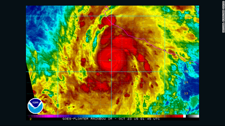
Friday morning, the storm was centered 145 miles (235 kilometers) southwest of Manzanillo, Mexico, and 215 miles south of Cabo Corrientes.
Moving to the north-northwest at a 12-mph clip, it’s forecast to pivot north later Friday morning before turning more north-northeast ahead of its afternoon or evening landfall.
A hurricane warning, which means hurricane conditions were expected within 24 hours, extends from San Blas to Punta San Telmo. A larger area, from east of Punta San Telmo to Lazaro Cardenas, is under a hurricane watch.
Mexican authorities worked to get ready for, and get the word out, about the onslaught.
In a meeting that started Thursday night and extended into the next morning, President Enrique Pena Nieto directed members of his cabinet to take immediate actions in the face of what was then predicted to be the strongest in the eastern Pacific in the past 50 years, according to the official Notimex news agency.
Officials were urged to alert those on the coast, especially those in the states of Jalisco, Colima and Nayarit. Classes were canceled Friday at schools in many of these locales ahead of the storm.
The preparations included piling up sand bags along beaches in places like Manzanillo in hopes of blunting what’s expected to be a significant storm surge.
The National Hurricane Center also warned about swells that “are likely to cause life-threatening surf and rip current conditions.”
In addition to these surges, rough surf and powerful winds, Patricia is expected to dump 8 to 12 inches of rain — and possibly 20 inches in some spots — along the Mexican coast.
“These rains could produce life-threatening flash floods and mudslides,” the U.S. weather agency said.
One other thing alarming about Patricia is its rapid rise in intensity. It rated as a tropical storm early Thursday, but 24 hours later it had become a Category 5 hurricane.
The storm is expected to roll over Mexico’s Sierra Madre, likely significantly dulling its intense winds in the process. But much of the system’s precipitation should roll on — potentially up to Arkansas, Louisiana and Texas, a state that’s now facing 3 to 6 inches in many locales from another system.
Still, while the Patricia-related rainfall could be significant in the United States, it pales to what people in Mexico will experience.
Those on that Latin American country’s west coast are no stranger to tropical storms, of course. But Patricia is special, in part because of the global, regular weather phenomenon known as El Niño.
Among other effects, El Niño has contributed to ocean waters off Mexico being 2 to 3 degrees warmer than usual.
“That warm water from El Niño probably just pushed this slightly over the edge to be the strongest storm on record,” CNN’s Myers said.
About the only good news about Patricia, as of Friday morning, was that its center was fairly compact, with hurricane-force winds only extending 30 miles out from its eye.
That’s a plus for anyone who gets brushed by the hurricane, but no consolation for those — perhaps in Manzanillo — who get hit directly.
“That’s almost like an F4 or F5 tornado that can be 5 or 6 miles wide, just tearing up the coast as it makes landfall,” said Myers, the CNN meteorologist. “… Can you imagine being the center of this eye, … and then get hit by the eye wall doing 200 mph?
“It will be a devastating blow.”