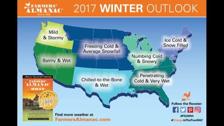
Well, it’s August; the hottest part of summer is over and the cool days of fall are around the corner. It also means it’s time for the Farmer’s Almanac to whip everyone into a full-blown-winter-storm-bread-and-milk-emergency with the snowy winter weather forecast.
Some people swear by it. Is there any truth to it? We’ll probably never know because they’re not transparent with how they forecast or how they calculate their claim of being “80% accurate”.
I imagine they use a blend of climatology, common sense, & broad statements that seem to verify to the person reading it.
For example, I’ll do one now and remind in 5-months how well this worked
“January 8th-14th: Very cold episode, ice storm across the mid south with blizzard conditions in the northern plains.” And remember, you heard it here first!
The Farmer’s Almanac uses a “secret formula” that’s (according to them) “locked in a black box in New Hampshire”. They claim they added things like: Climatology, Meteorology, & Solar Science recently to improve their accuracy. Yes, all of those variables do affect weather patterns but to what extent they’re used in their forecast is unknown because they don’t tell anyone how they do it.


The short answer is it’s probably not much more accurate than calling Ms Cleo for a pay-per-call psychic reading or changing your spring break plans based on the Groundhog Day forecast.
It’s intriguing but there’s not much substance to the scientific methods behind the forecasting.
So how would a meteorologist forecast winter this far out? Well, a smart one probably wouldn’t but if you were interested, there are some hints in the global trends that might point us in the right direction.

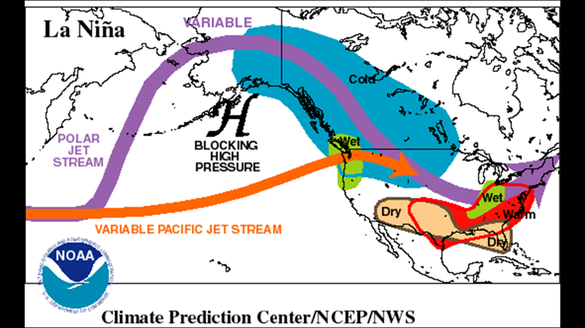
A “weak La Niña” winter looks likely this winter. It might not be as pronounced as this CPC image but it could lead to drier and warmer conditions locally.
This is much different from El Niño winter’s (i.e. last winter) which are very wet and usually warmer.
Locally, the presence of an El Niño or La Niña doesn’t affect our temperature as much as it affects the amount of rainfall.
There is at least one variable that correlates very well with a snow/cold pattern for us and it’s call the North Atlantic Oscillation (NAO).

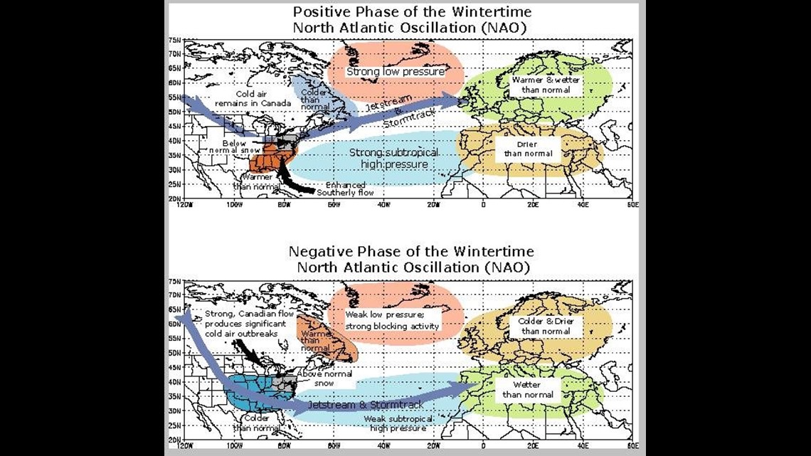
A negative phase of the NAO all but guarantees repeated cold blasts from deep in the Arctic. When moisture coincides with the cold it’s easy to have a snowy and cold winter. The NAO is calculated by comparing conditions in Greenland to conditions in the Azores.
Here’s the thing, the NAO cannot be forecast accurately more than about a month in advance.
It’s simply too early to know what the NAO will look like this winter.

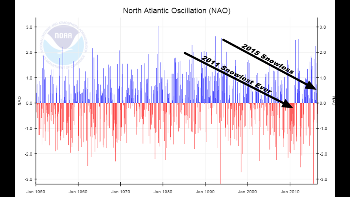
This shows the NAO for the past 50+ years. That big extended stretch of red was the icy cold winters of 2009, 2010 and 2011 when we had repeated blasts of snow and the coldest/snowiest winter on record for many places in West/Northwest Arkansas.
Fayetteville had a seasonal record with 27″ in 2010, the historic 18.5″ in one day in 2011 of and who can forget the crippling Springdale Ice Storm of 2009?
Look at the image above. You can see last year there was more blue than red which is one of the reasons it was warmer than usually though.
Remember, all it takes is one negative NAO to overlap with moisture even in a warmer than normal year to create a single snow or ice storm that everyone remembers.

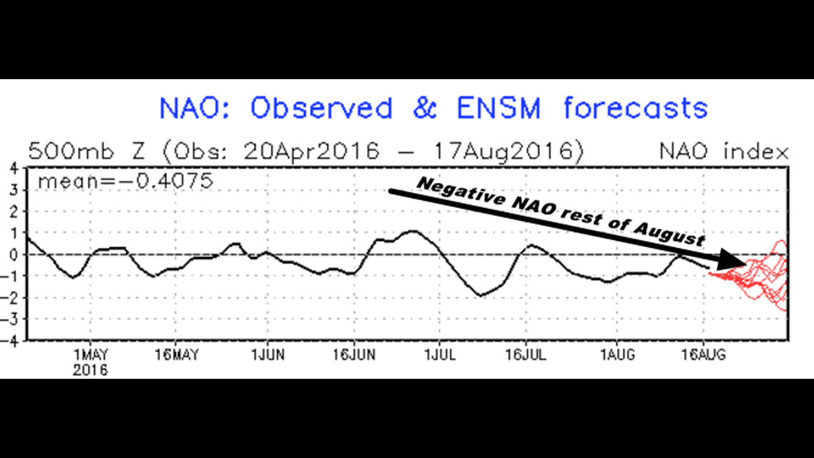
This is the current NAO forecast for the rest of August.
SPOILER ALERT: It’s going to be cooler than normal for the next two weeks which is why we have a high confidence in the forecast for temperatures in the mid to upper 80º thru the end of the month.

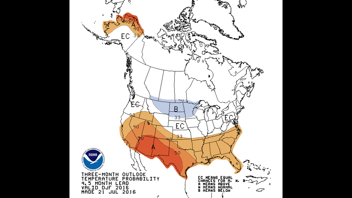
For what it’s worth (and it’s not much) the months of December-January-February are forecast to be warmer than normal from the Climate Prediction Center. A weak La Niña was probably a factor in this forecast. The El Niño/La Nina pattern can be forecast reasonably well several months in advance by measuring the trends of warming and cooler in the Pacific as well as pressure changes across the Pacific.
So, what about the Farmers Almanac?
Well, the dramatic headline is probably an excuse to sell Almanac which regrettably I’m probably helping them accomplish with this blog post. But the real answer is it’s simply too early to know what the Winter of 2016-2017 will hold and if the current trend holds; you would expect slightly warmer and drier conditions going into the winter months.
Personally, I think it will be FAR drier than last year’s winter without El Niño present and I imagine we’ll probably have at least one or two cold outbreaks with snow which coincide with a negative NAO pattern. We normally have 7″ in Northwest Arkansas and around 5″ in the Greater Fort Smith Area and until there’s some other reason to think otherwise this seems like a good bet for the upcoming winter.
-Garrett