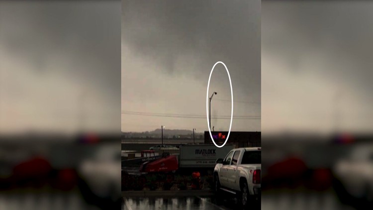
The National Weather Service has confirmed an EF-0 tornado in Sebastian County from Tuesday’s storms.
The tornado briefly touched down on the SE side of Fort Smith with estimated winds from 75-85mph.
Dual Polarization radar detected debris in the radar beam due west of the Fort Smith Regional Airport, the storm weakened as it tracked east.
OFFICIAL STATEMENT FROM NATIONAL WEATHER SERVICE:
...NWS DAMAGE SURVEY FOR 03/27/18 TORNADO EVENT...

.OVERVIEW...A brief tornado developed just south of Fort Smith,
Arkansas during the morning hours of March 27th. This tornado formed
along the leading edge of a bowing severe line segment of
thunderstorms as it approached the KFSM Fort Smith WSR-88D.

.Bonanza Arkansas Tornado...

Rating:                 EF-0
Estimated Peak Wind:    75 to 85 mph
Path Length /Statute/:  2 miles
Path Width /Maximum/:   350 yards
Fatalities:             0
Injuries:               0

Start Date:             March 27 2018
Start Time:             943 am CDT
Start Location:         2.2 NNE Bonanza / Sebastian County / AR
Start Lat/Lon:          35.2704 / -94.4168

End Date:               March 27 2018
End Time:               945 am CDT
End Location:           3.7 NE Bonanza / Sebastian County / AR
End Lat/Lon:            35.2806 / -94.3840

Survey Summary: This tornado damaged or destroyed several barns and
snapped numerous large tree limbs as it moved east-northeast within
the Cedar Creek valley, north of Highway 45.

EF Scale: The enhanced Fujita scale classifies tornadoes into the
following categories.

EF0...weak......65 To 85 mph
EF1...weak......86 to 110 mph
EF2...strong....111 to 135 mph
EF3...strong....136 to 165 mph
EF4...violent...166 to 200 mph
EF5...violent...>200 mph

Note:
The information in this statement is preliminary and subject to
change pending final review of the event and publication in NWS
Storm Data.
-Garrett