The tropical system Isaac has continued to churn with heavy rain and strong winds in Louisiana.
Over the next 48 hours the tropical low will be influenced by an area of high pressure shifting across the middle of the United States and will pick up speed and move into our area.
Rain and gusty winds are expected. The heaviest rain is currently forecast for Central Arkansas.
Because tropical systems are unusual for Arkansas and Oklahoma, I thought I would detail what to expect as the system arrives and departs.
Tropical systems thrive in the absence of upper level winds which makes their forecast track difficult because upper level winds are typically what steer most systems.
***Please note the details below can change from hour-to-hour and day-to-day, check back with 5NEWS as the system track becomes clearer. This post reflects data from Aug 29th***
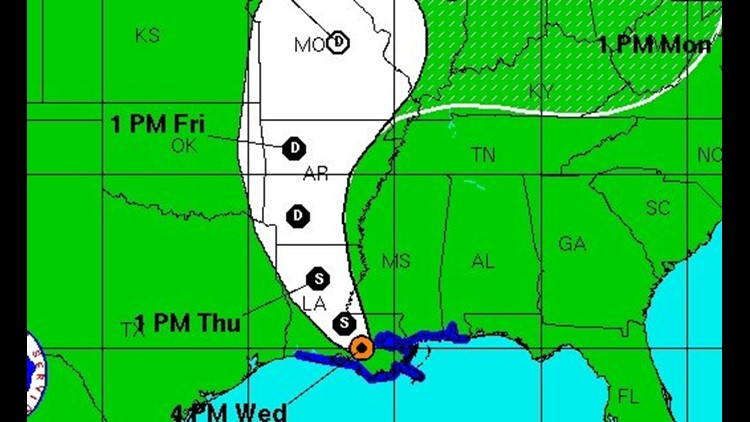
TIMING: The heaviest rain will extend about 150 miles east and around 80 miles west of the center of the storm. I’ve been looking at forecast tracks with numerical computer model guidance and think splitting the difference between two of the main models would be the best option at this point. With a general track from Shreveport, LA to Fort Smith, AR to Springfield, MO.
By 7 p.m. on Thursday, I would expect the center of the low to be near Texarkana or Shreveport with outer rain bands already moving into Little Rock and possibly as far north as Hot Springs or Fort Smith.
By 7 a.m. on Friday, I would expect the center of the low to be somewhere between Poteau and Fort Smith. Heavy rain that started overnight will be likely in much of the area for the morning drive.
By 7 p.m. Friday, I would expect the center of the low to be somewhere from Siloam Springs to Branson to Eureka Springs. Heavy rain will be ending or have ended late in the day Friday.
By Saturday at Noon: I would expect the center to be located between Kansas City and St Louis. The only remaining rain on Saturday will be wrap around moisture on the back side of the low. I’m seeing a lobe of energy in the middle of the atmosphere (vort max) rotating on the backside around 2 p.m.- 6 p.m. And that could lead to an additional rain Saturday afternoon for Razorback tailgaters; however, the majority of the energy from the tropical system will be out of the region at game time. Rain should be ending or be lighter in intensity for the Razorback Home Opener.
RAINFALL TOTALS: The gradient will run from the east to the west with the highest totals on the east side of the low and the lower totals on the west side. A “middle of the road” approach would give us around 1-3″ across much of the area. Realistically… there will be some places in eastern Oklahoma that don’t receive more than .50″ and there will be some places near Russellville (based on current track) that could see as much as 4 or 5″. On average, expect 1-3 with locally higher amounts depending on the track and the east-west gradient. Tropical rains occur in bands, meaning we could see an hour of heavy rain then nothing for a few hours followed by another hour of rain. We don’t expect it to be non-stop all day, but there will be numerous bands rotating around the low.
LIGHTNING AND HAIL: Tropical systems are “warm core” systems. There isn’t a significant vertical wind that causes the friction of water and ice which leads to both electrical charges and hail production. As a result… there will likely be no hail with this system. Cloud to ground lightning strikes will occur but will be uncommon. As the system transitions and weakens from a hurricane to a tropical cyclone to extratropical cyclone the cold air will eventually form aloft with lightning and hail becoming more common. That will likely not take place until the system arrives in the midwest sometime on Sunday or Monday.
TORNADOES: Tornadoes will occur in the outer rain bands in the northeast quadrant of the spinning system. This is a result of surface friction, the Coriolis Force, and a few other factors that increase the shear on the northeast side. Tornadoes will be even more common if the sun comes out between the rain bands and increases the surface instability. We are concerned that a few tornadoes will occur in Arkansas on Friday afternoon. They will not be long-lived and they will not be violent/significant tornadoes. We’re talking about brief areas of rotations that occur for a few minutes and usually have winds and damage associated with lower ratings on the Fujita Intensity Scale: EF0s to EF2s.
WIND DAMAGE: The system will arrive in Arkansas as a Tropical Depression. By definition, the system will have winds up to around 40mph. We do not expect damaging winds or broken power-lines. This will not be like Hurricane Ike that pressed up against a cold front and caused 70mph gusts back in 2008. A windy day with winds occasionally gusting to 40mph+ will be likely.
TRAVEL IMPACTS: Hydroplaning of vehicles seems to always be a problem during heavy rain. Early morning on Friday and into the afternoon is when the heaviest rain is expected. Air travel could be impacted with delayed flights as bands of heavy rain move across the area. It’s unlikely we’ll see widespread cancellations.
I hope this helps you as you make plans around the weather or into the weather as this tropical system arrives. Most of us will enjoy a breezy and rainy Friday with some much-needed rain. It’s possible that many burn bans could be lifted next week. Please check back with 5NEWS during this event and details can… and WILL change as the system track becomes clearer and better defined.
-Garrett Lewis