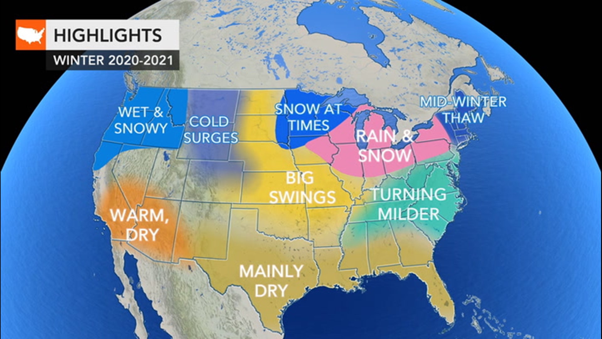
As Americans brace for a long winter heading toward the end of what has been a taxing year, AccuWeather forecasters are encouraging people to set up holiday decorations before Thanksgiving.
In a conference call with reporters on Tuesday, AccuWeather Lead Long-Range Forecaster Paul Pastelok encouraged hanging outdoor Christmas lights early ahead of the winter season, which officially begins on Dec. 21. Now-ish is a good time to get to work on those outdoor holiday decorations, he said.
"Mine are up!" Pastelok laughed, adding that he had chosen to take advantage of the warm spell that enveloped the Northeast in recent days thanks to the influence of Tropical Storm Eta. He encouraged others to do the same as the United States buckles down for what could be prolonged winter weather that could include harsh conditions even extending well into March.
Factors driving the U.S. winter weather forecast
A La Niña weather pattern, the cooler phase of the El Niño-Southern Oscillation (ESNO) climate pattern across the central and eastern Pacific Ocean, along with a weak polar vortex and western Atlantic temperature anomalies will be among the contributing factors of the winter weather this season.
La Niña weather patterns typically lead to a stronger, more frequent northern storm track over the U.S., with heavier precipitation for the Northwest and drier weather for the South. Pastelok noted this would be the "main driver" of the winter weather this season.
As for the western Atlantic, temperatures have been running above normal, which will influence cold air as it reaches the East, according to Pastelok.
Cold air could modify and warm up as it encounters the mild Atlantic waters. Because of that, it will be "harder to get cold air masses to stick in the East," Pastelok said, adding that's why his team is predicting a mid-season thaw with above-normal temperatures during January and February in the East.
As for the third factor, the term "polar vortex" grabbed the attention of headlines after a lapse in the upper-level low pressure area centered over the North Pole caused a breach of bone-chilling air to seep into the states during the winter of 2018 into 2019.
The weakening of the polar vortex can result in just that -- cold air pushing the boundaries into areas with generally more mild air. A stronger polar vortex, as is expected for most of this season, tends to hold the colder air back. However, toward March, it could weaken and the U.S. could see bitterly cold weather, resulting in what could feel like a prolonged winter.
What to expect for Thanksgiving and Black Friday
Black Friday deals have hit the shelves early this year, not only encouraging early shopping ahead of the holidays but also emphasizing the importance of the weather during the early weeks of the season.
After Eta's influence wanes, a chill will come over the northeastern U.S., though temperatures could bounce around a bit. Regardless, one or two potential big storms in New England may interrupt holiday shopping and traveling before Thanksgiving. Nor'easters could develop and lead to coastal flooding, wind damage and drifting snow events in New England, Pastelok warned. However, the holiday itself in the region should remain dry with chillier air ahead of a warmer holiday weekend.
The mid-Atlantic into the southern U.S. will experience more mild weather, though an occasional chilly bout, meaning outdoor dining is likely to be able to continue into at least early December. Severe weather threats such as thunderstorms may still be possible into the winter months, but they likely won't carry a large impact on holiday shopping and shipping as in the Great Lakes and Midwest.

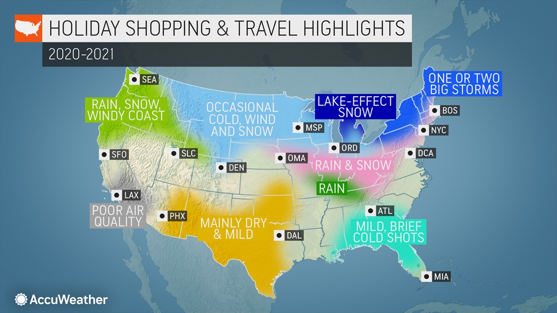
Cold fronts may stir up several rounds of gusty to severe thunderstorms in the lower Mississippi Valley from November to early December, though the southern Plains and Gulf Coast should see less concerns. The central Gulf states into Tennessee and into the interior Southeast may have a few isolated severe weather events in December into February.
A northern storm track could bring quick-moving storms through the Great Lakes and Ohio Valley regions, resulting in frequent lake-effect snow for the areas during both holiday periods, creating the possibility of slippery conditions or impassible roadways. The more northern areas are likely to experience above-average snowfall as rain and ice target areas farther south across Missouri, Illinois and Iowa.
Farther to the west, a couple storms my impact Colorado and eastern New Mexico with mountain snow, rain and brief cold weather, but a spaced-out timing between the storms should keep any disruptions in holiday shopping to only a few days.

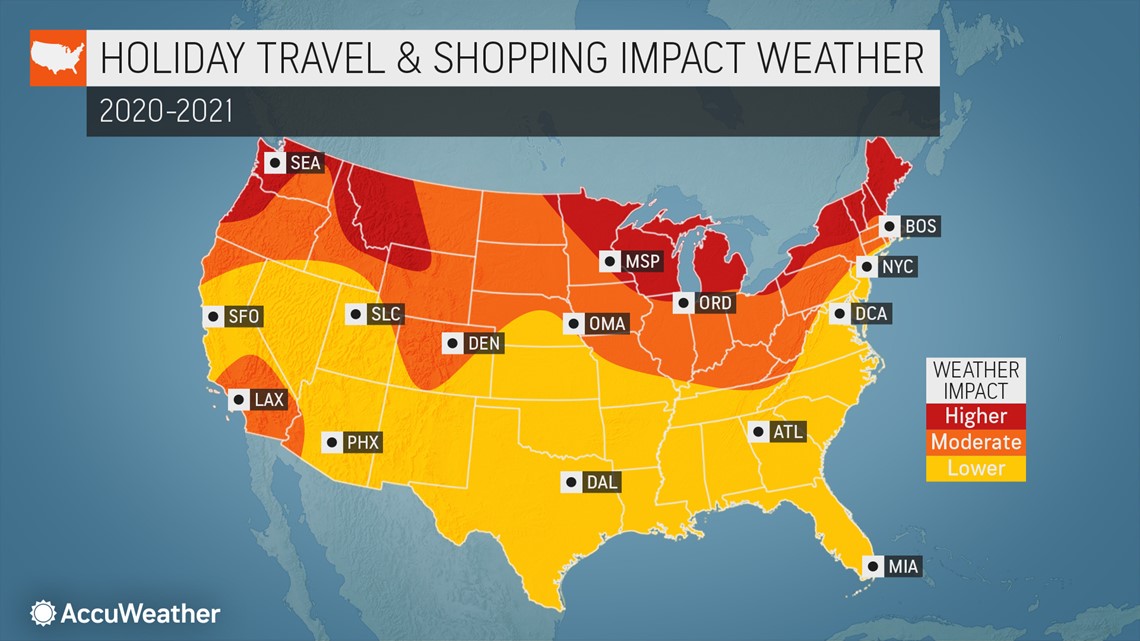
Similarly, heavy rain, snow and a windy conditions will make for rough travel through the passes in the Pacific Northwest and northern Rockies from November into the new year. Shoppers should prepare for wet and windy conditions, which could lead to travel delays at times.
Alternatively, parts of Southern California will face localized visibility not from snow squalls or showers, but from smoke as the wildfire season in the state as well as western Arizona extends into December.
Due to the persistent wildfires, any precipitation can lead to flooding and mudslides in charred areas of California and Oregon, which could force road closures in some locations.
Dry and seasonable conditions should provide for pleasant travel, shopping and dining for the Southwestern part of the county through the end of the year.
Chances of a white Christmas
This winter season holds good news for snow lovers in the northern half of the nation. In addition, areas of northwestern Washington to northwestern Nevada and areas from Iowa to Ohio to areas of northern Tennessee may have higher chances for a white Christmas compared to normal.

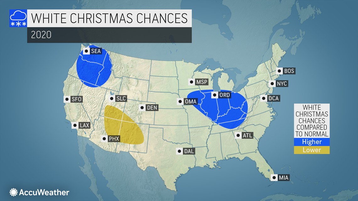
Conversely, much of Arizona, New Mexico, Utah and Colorado, including the southern Rockies, will face a lower-than-normal chance for snow.
Skiing Season Outlook
Thanks in a large part to the La Niña pattern in place, winter weather will provide excellent skiing conditions across most of the northern swath of the country. At times, frigid air in the northern Rockies and Midwest as well as icy periods possibly around midseason in New England and upstate New York may keep people from the slopes, but the snow season may make up for it for ski resorts in these areas with snowfall possibly lasting into the spring.
The Midwest is also set to benefit from the cold shots for snowmaking operations, and a variety of lighter and heavier snow events expected throughout the season could add some fresh powder to the slopes.

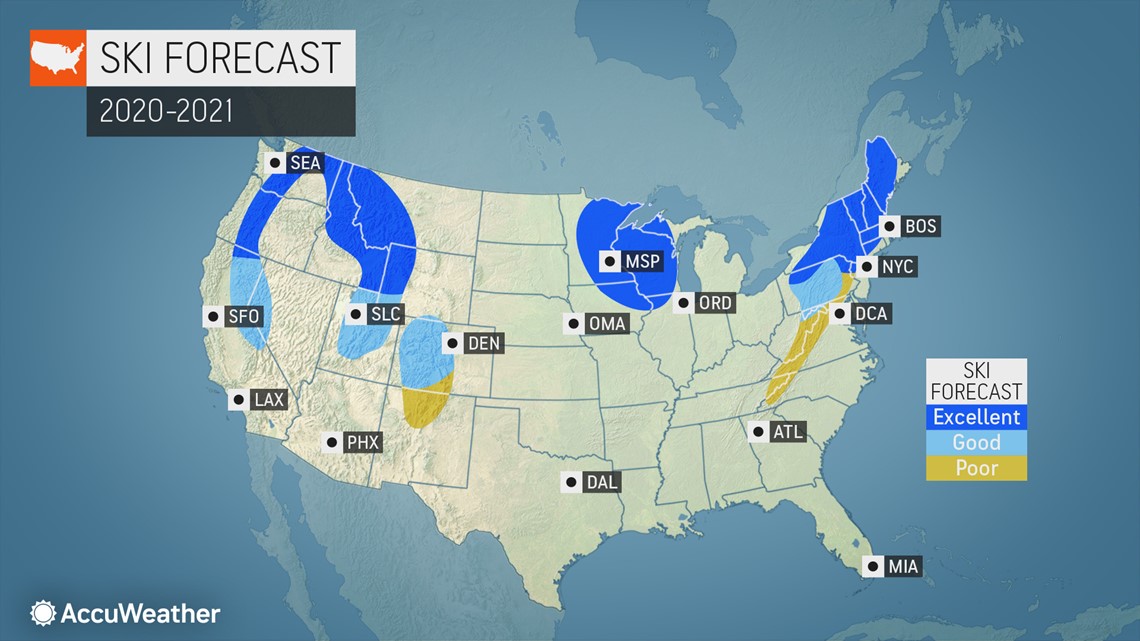
Skiers in Colorado and Utah are expected to face a roller coaster ride of a season. Winter conditions will at times bring cold and snow, but more mild and drier conditions are anticipated for other periods. Additionally, big gaps in snow events are expected for the two states.
Across the nation, those seeking to hit the slopes and escape the confines of home may not be in luck this season. Central Appalachia and the mid-Atlantic are expected to experience poor skiing conditions at least into December due to warmups that can lead to melting and icy spots.
The impact of winter weather events on COVID-19 precautions
The novel coronavirus has seeped into nearly every nook and cranny of everyday life, from pushing schools to use more online classes to prompting some stores to enforce stricter capacity limits. Here are some concerns with how the weather could play into these.
The number of storms will be less of a problem for the southern half of the U.S., but areas in the northwestern U.S. and Great Lakes region should be prepared for not just snow, but high wind events that can threaten power outages and potentially cause disruptions to remote work and learning. High winds cannot only cause power outages, but also prompt delays at airports for anyone traveling by air over the holidays.
Consumers should keep in mind that COVID-19 has also caused delays in shipping for some producers, which may add further stress if any dangerous winter weather adds to timelines.
Areas to watch for ice events will extend from Missouri to Indiana to northern New England, Pastelok said. Power outages from these ice events can rival those even caused by hurricanes, plunging households into a period without active heat if precautions aren't taken ahead of time. Online classes may also be interrupted by these events in a power outage, Pastelok pointed out.

