FAYETTEVILLE, Arkansas —
Monday 3PM Update:
Beryl's outer bands have already began moving through the area bringing heavy rains to parts of the area. Some will see a break before overall coverage and intensity increase this evening, into the overnight hours.
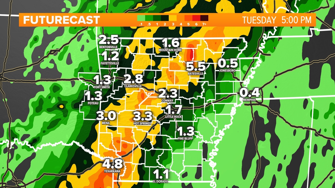
There have been two things change. First, the center of the storm has shifted slightly east. Second, it's moving a bit quicker. These two things will lessen the amount of rain we exepct to accumulate. Broadly speaking, most of the area will pick up between 1-3 inches, with some locally heavier amounts not out of the question. The eastern third of 5COUNTRY stands to see amounts on the higher end of that range. This would include places such as Johnson and Logan counties.
- Skot
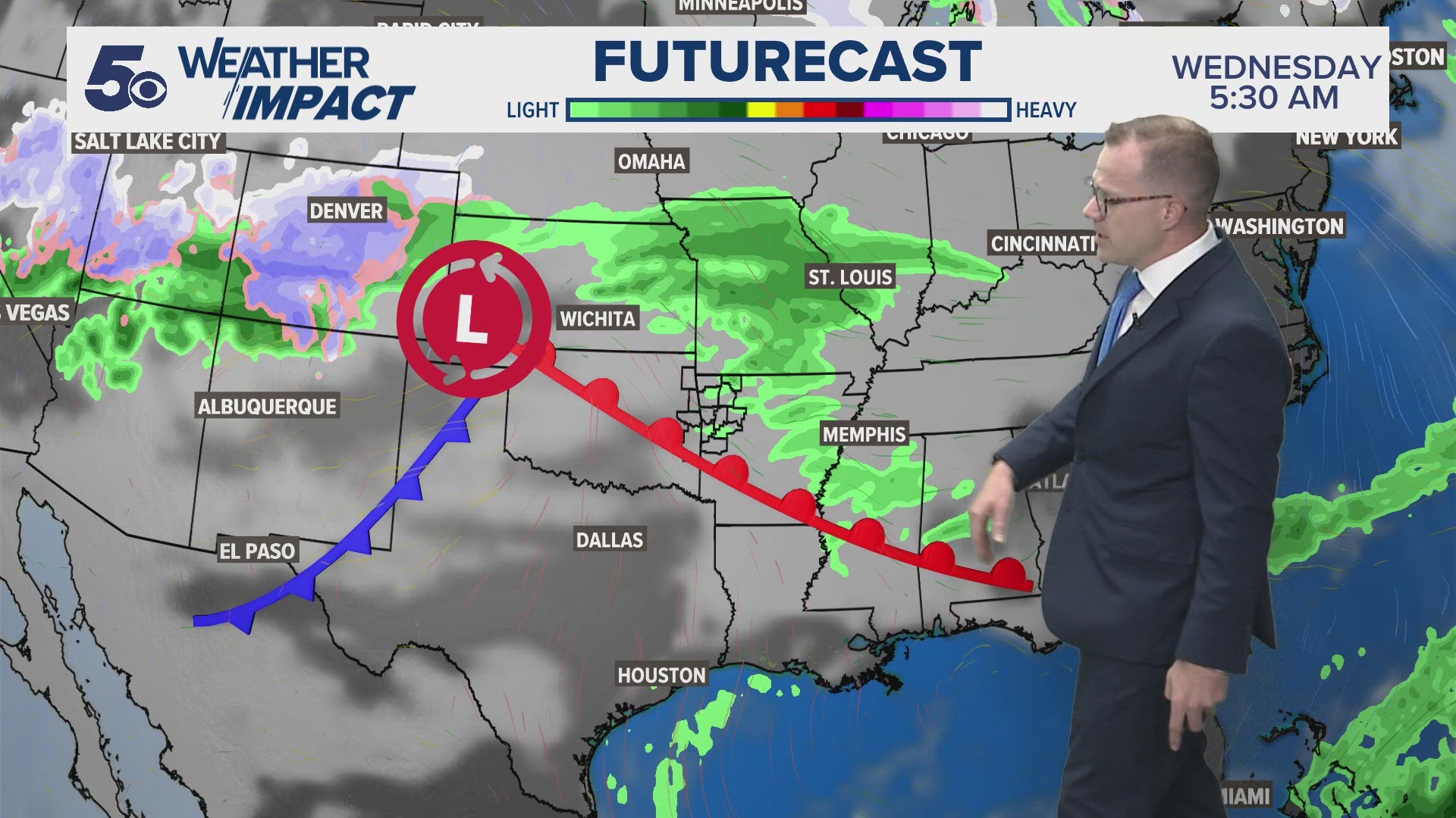
Beryl is rapidly lifting across east Texas Monday afternoon, after making landfall along the Texas coast as a category 1 hurricane a little before 4AM. It will continue tracking north, eventually into Arkansas. As it travels north, it will weaken into a tropical depression. Even still, as it weakens it will bring with it a deep plum of tropical moisture. The atmosphere will try to wring out as much moisture as possible over parts of eastern Oklahoma and Arkansas.
You can track Beryl as it makes its way through Arkansas using our live interactive radar by tapping here.

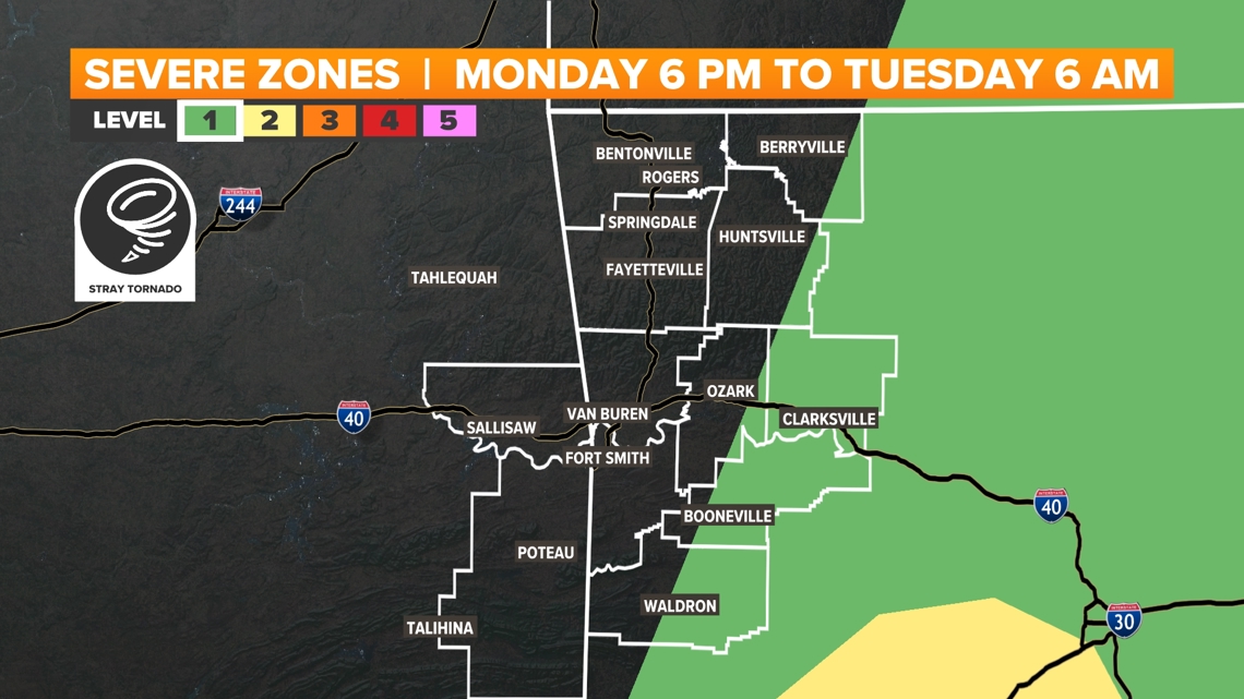
What impacts should we expect in Arkansas?
The strength of tropical systems grows largely due to warm ocean waters. When Beryl moves inland over Texas, it'll lose that source of energy and begin to slowly weaken from a hurricane to a tropical depression. Even with such weakening, Arkansans will still see some impacts.
Rain
Primarily, we'll see some much-needed rainfall. Most forecast guidance suggests 5COUNTRY can see on average 2-4 inches of rain between Monday afternoon through noon Tuesday. It's important to note that there will be exceptions to this rule. Some will see less, others may see more. There will be a sharp cutoff between the highest axis of rainfall accumulation and notably lesser amounts. It's all about where the exact track sets up. Even a small shift in the track will result in big changes to the forecast.

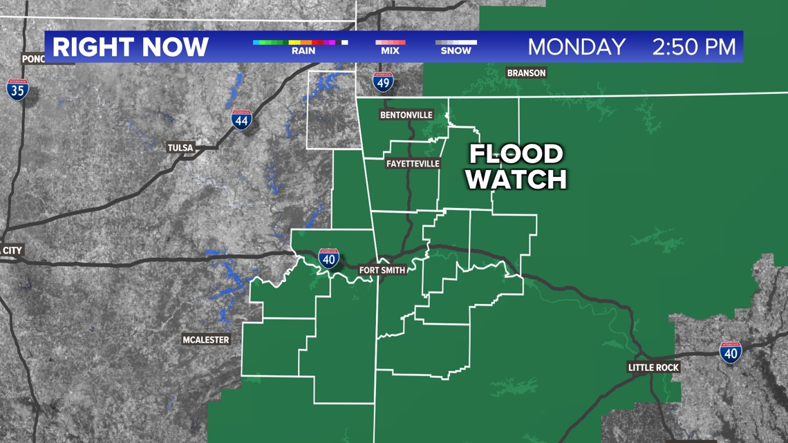
Some flash flooding will be possible, especially in low-lying and poor drainage areas that are typically prone to flash flooding. The National Weather Service has placed most of 5COUNTRY under a *FLOOD WATCH* through lunchtime Tuesday. Some locally higher amounts of 4 to 6 inches will be possible, especially for areas near and south of the River Valley.

Wind
We can also expect gusty winds. Gusts between 20-30 mph will be common, with some instances of 40 mph gusts not out of the question. These winds aren't considered "severe," but loose lawn furniture, trash cans, and small limbs may be impacted. Widespread power outages are not likely, though some isolated outages are possible.
Small tornado risk
Brief spin-up tornadoes are often associated with the right front quadrant of tropical systems. Given the current track of the storm, this would bring a small tornado risk to portions of the River Valley, including Scott, Logan, Franklin, and Johnson counties. Again, even a small shift in the track may change this.
These types of tornados often spin up very quickly and are generally EF0s and EF1s. Even though this potential is low, the 5NEWS Weather Team will be tracking the system very closely just in case.

When can you expect impacts to begin?
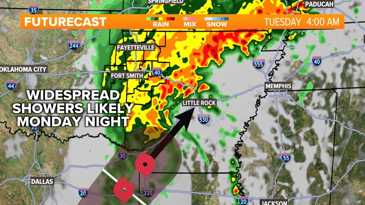
The outer bands of Beryl will be moving into the area from the south to north starting early Monday afternoon. The frequency of these downpours will increase through Tuesday morning. The heaviest rain is expected Monday night, with widespread rainfall likely lingering through our Tuesday morning commute. Shower activity will taper off from west to east across 5COUNTRY.
The strongest wind gusts will be found closest to the center of circulation — where the eye of the storm would be found. This is expected to move through our area beginning very early Tuesday morning and exiting by Tuesday afternoon. The highest gust of winds will likely be between 4 a.m. and 9 p.m. on Tuesday.
You can find the latest hour-by-hour forecast by tapping here.
What do you need to do to prepare?
For many of us, Beryl will bring much-needed rain! However, some flash flooding looks likely. We highly recommend remaining weather aware and having a way to receive weather warnings should they be issued.
Flash flooding will be most common in low-lying areas where the heaviest band of rain sets up, which is largely dependent on the track. If you live in an area that routinely floods with heavy rain, you should expect much of the same.
Remember to not cross flooded roadways. It's often impossible to know whether or not the road below has washed away or not, and it only takes a few inches of water to stall a vehicle.
We also recommend securing loose lawn furniture and trash cans.
Those in the eastern half of the River Valley should monitor conditions and have multiple ways to receive weather warnings in the event a tornado warning is issued. These types of tropical tornadoes spin up very quickly unlike a "traditional" tornado, so it's important to remain weather aware.
Watch 5NEWS on YouTube.
Download the 5NEWS app on your smartphone:
Stream 5NEWS 24/7 on the 5+ app: How to watch the 5+ app on your streaming device
To report a typo or grammatical error, please email KFSMDigitalTeam@tegna.com and detail which story you're referring to.