
ARKANSAS, USA — It's been a stellar first week of December so far, but that's about to change. Strong north winds are on the way with some scattered showers and thunderstorms across Arkansas from Friday night through Saturday night. The Friday night round in western Arkansas looks weak. Stronger storms are possible in eastern Arkansas on Saturday evening.
Tap here for our interactive radar to track the storm as it pushes east across the nation.
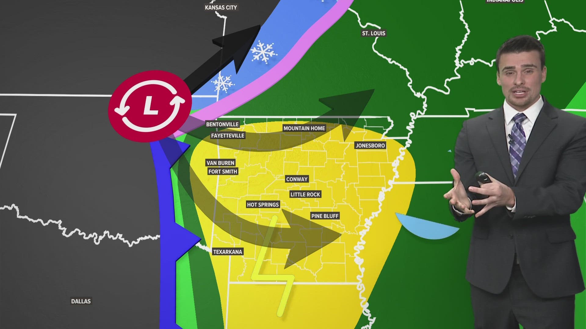
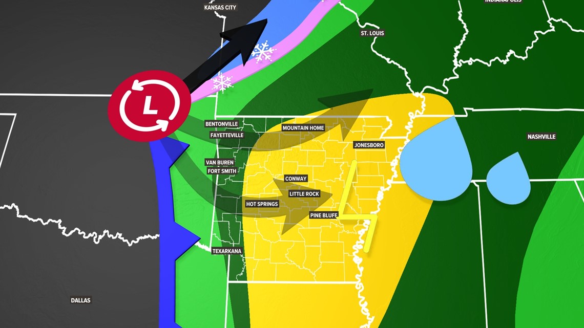
There are two things to note about this storm: It is moving faster and farther to the north. These two factors reduce snow threats to a bare minimum while enhancing storms in eastern Arkansas and weakening storms in western Arkansas. Overall, this is going to be a showery storm system with some scattered thunderstorm threats, especially south and east of Little Rock. The severity looks minor. Any snow chances would come as stray flurries in Northwest Arkansas (NWA), but the chance is low. Better flurry chances are in Missouri.
General forecast
- Western Arkansas: Showers and thunder Friday night, shower possible Saturday morning, very stray evening drizzle or flurry (NWA)
- Central Arkansas: Scattered rain Saturday morning, storms Saturday afternoon
- Eastern Arkansas: Stronger storms possible Saturday afternoon and evening
Tap here for the latest forecast in 5COUNTRY.
What is the track?
Our weekend storm is moving so much faster that it doesn't have time to dig south. It is moving farther north. That is pushing snow chances back to the north too. Storm chances are also moving farther north. We will be on the warm side of things during the precipitation window. By the time temperatures drop below freezing, most of the moisture will be gone.
Colder weather is moving north where the black arrow points. The other arrows are the previous possible paths of the storm. There's always the chance this storm reverses course, but that chance seems low right now.

Let's go timestamp by timestamp
Friday night
Our cold front will begin its approach into Arkansas. Thunderstorms may develop as south winds keep temperatures in the 60s Friday night. This is a low-end severe threat. Anywhere in the green zone will have the chance for some severe storms. Hail would be the highest threat. There is a very low-end wind and tornado threat.

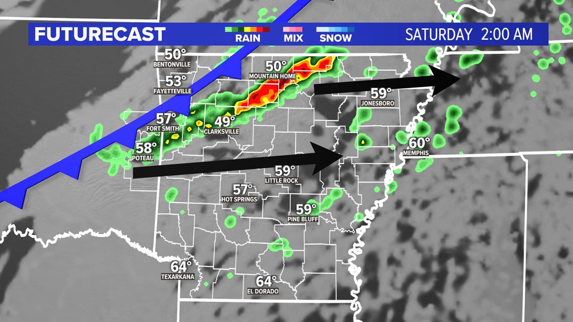
Saturday morning
Scattered showers are possible early across Arkansas. The rain will be mostly done in Oklahoma. NWA and the River Valley will dry out in the morning after scattered rain the night before.
Saturday afternoon
There will be thunderstorm chances. in central and eastern Arkansas
Saturday evening
Most of the rain will be done by Saturday evening. There could be some patchy drizzle or flurries across western Arkansas and eastern Oklahoma, but the chance is very minimal. There will likely be some clouds breaking in the evening. Strong storms are possible in eastern and southern Arkansas.
Q: My parade is on Saturday. Am I good?
A: Yes! Just watch for the wind and dropping temperatures. High temperatures will be in the morning and then temperatures will drop the rest of the day.
Sunday
All clear! Mostly sunny skies are expected but it will be chilly!
Check back for more updates.
Watch 5NEWS on YouTube.
Download the 5NEWS app on your smartphone:
Stream 5NEWS 24/7 on the 5+ app: How to watch the 5+ app on your streaming device
To report a typo or grammatical error, please email KFSMDigitalTeam@tegna.com and detail which story you're referring to.