
ARKANSAS, USA — UPDATE: As of Tuesday evening, our weekend storm system is trending toward a northern track. This would increase rain and thunderstorm chances, and reduce snow chances. For a new breakdown, tap HERE.
Arkansas has had it pretty easy so far this fall, but as winter approaches, so do the winter storms.
Tap here for our interactive radar to track the storm as it comes in from the west.
Arkansas' first possible wintry system is coming December 9-10. A deep low-pressure system from the Gulf of Alaska will drop south into the southern Plains, creating a mess of severe storms especially south of I-40, and possibly snow showers north of I-40. Everyone will start with rainfall, but the question is: by nightfall Saturday evening, how cold will temperatures drop?
Everything about the weekend forecast revolves around the storm track.
--OUTDATED FORECAST--
Head to the 5NEWS forecast page for updates.
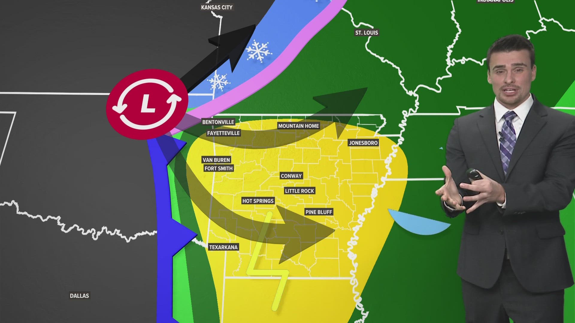
General forecast: Friday night - Saturday evening
- Showers to dry skies: North, West, and Mountains
- Rain & Thunder: Central
- Severe Storms: South
Before the storm
The first full week of December looks mostly sunny and quiet in Arkansas. Winds will change directions at times, but expect lots of 50s and 60s this week leading into the weekend. A few high thin cirrus clouds are possible at times, but no rainfall. Our winter storm won't arrive until Friday night. That's when the first rain showers will hit.
The week leading up to the forecast is important for two reasons. First, how warm we get can enhance the strength of the storm and also increase severe weather chances. Once temperatures get above 65, severe weather becomes more probable. Secondly, a really warm week will make it tougher for snow to stick in the towns that get snow showers, especially on the roads, thanks to warmer ground temperatures.
Our first snows of the season usually do not mess the roads up too much, unless we get blasted with several inches. Even then the heaviest of snows do not last very long on the roads and dirt spots. Snow on cars, grass, trees, and roofs can last longer.
During the storm
There are a few things we know, and a lot of what we do know. Let's start with what we are pretty sure about...
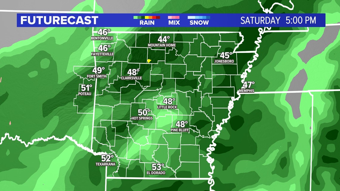
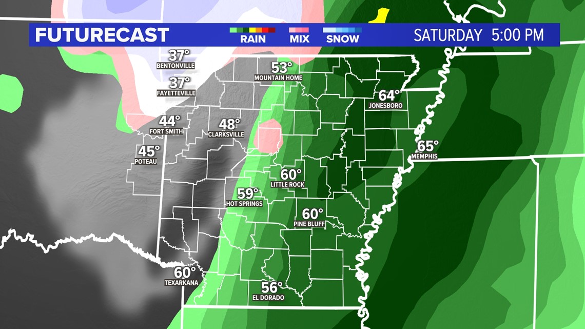
Rain is likely everywhere in Arkansas and eastern Oklahoma before the cold front arrives. The rain will begin Friday evening and last through Saturday evening. Generally, we are expecting about half an inch to a full inch of rain. There may be some rumbles of thunder Saturday morning, especially in southern Arkansas.

Depending on how warm we get, there may be some severe weather across the Mid-South and Gulf Coast. Southern Arkansas has the highest chances for severe hail and a couple tornadoes. Severe weather needs warmth to support it, so the farther south you go, the more on watch you need to be for severe weather.
The yellow areas highlight severe storm chances.
What happens next?
Once we get the rain on Saturday, do we keep with rain showers and dry out, or do we switch to snow showers? That is all dependent on our storm track. How far or south does the low pressure go, and at what time?

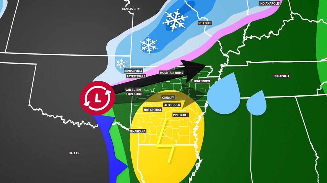
The low pressure will start in southern Oklahoma on its attack approach into Arkansas. Will it move east into central Arkansas? Will it move more north into NW and Missouri? We're not sure. Or somewhere in the middle?
SCENARIO 1: Northern Track (more warmth) THIS IS BECOMING MORE LIKELY
- Rain and storms possible Saturday morning and midday
- Heavy rain gone by Saturday evening, but some low clouds and patchy mist will be possible across much of Arkansas
- Snow chances mainly will stay north in Kansas and Missouri
- Can't rule out a stray snowflake Saturday evening and night in northern Arkansas; snow showers are possible
- Snow accumulations are not expected

SCENARIO 2: Southern Track (more cold)
- Rainy Friday night and Saturday, chilly all Saturday with 40s
- Rain starts to change to light snow showers after 10 p.m. Saturday north of I-40
- Breezy and chilly that night into Sunday
- Minor accumulations will be possible on cold surfaces and vegetation
- Couple slick spots on roads Sunday morning possible, nothing major
SCENARIO 3: Somewhere In Between
- Very rainy Saturday morning, drizzle and rain Saturday evening.
- A few snow showers are possible by 4 a.m. Sunday, mainly in northern Arkansas and northeastern Oklahoma
- Breezy and chilly Saturday night
- Probably no accumulations (except a couple of cars and mailboxes)
Your 5NEWS Weather Team wants to make sure you stay ahead of the storm. Something is coming on Saturday. We mostly likely will all get some rain at some point, but we are working on the cold air side of the weather equation. Get enough of it, and there may be some snow chances. Get too little of it, and there may be some thunderstorms to track.
For the latest 5COUNTRY forecast: tap here.