ARKANSAS, USA — I'm dreaming of a white Christmas! Mostly dreaming because snow may be hard to come by this Dec. 25, 2023, as warmer air surges north, especially in the central USA. (scroll down for a region-by-region look)
Tap here to track any incoming systems bringing rain or snow.
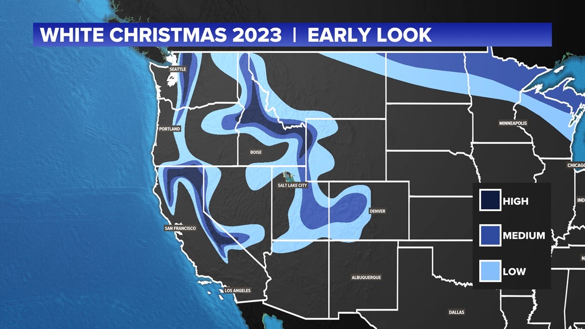
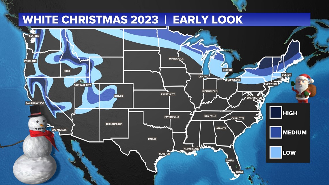
This is an early look at weather patterns for late December (forecast made Dec. 11). Check back for updates closer to Christmas.
Long-range weather setup
While still far out for specific details, plus changes are likely to be made, we can still look ahead to figure out what Christmas may generally be like across much of the United States.
We are watching the jet stream, which separates warm to the south and cold air to the north. Generally looking at data around December 23-25, the jet stream will be pushing northward in the central USA while pushing slightly south along the east coast and the west coast.
This map shows upper-level winds on top of lower atmosphere temperatures (850 hPa). You see some cooler air in the northeast and a closed low toward the Pacific Ocean. These are the two areas that may try to create some snow.
Snow chances
- Northeast and northern Great Lakes: It looks like there may be some lingering cold air heading into Christmas close to the US-Canadian border. With an active jet stream possible a day or two before Christmas, there may be some snow chances in the far north.
- West: If a storm system forms in the Pacific and moves east, it will likely dump more snow in the higher elevations while rain falls closer to sea level. There is already snow in these areas, so additional snow may be possible.

REGION: Northeast & Great Lakes
There are some low and medium snow chances north of I-90. This would be due to some light snow systems passing near the US-Canadian border a couple of days before Christmas. Areas in blue have the chance for some snow around Christmas morning, but it may not be much. If temperatures start warming again near Christmas Day, much of the snow may melt.
The darker blue areas in the Adirondacks may have higher chances of snow if a snow clipper passes by and then kicks up scattered lake-effect snow showers before Christmas. Most of these changes will be north of Syracuse, New York.
REGION: Northern Plains
You have to go way north...
This Christmas is likely to be on the warmer side, so you will have to go far north to see snow chances, mainly north of Chicago and Minneapolis. These snow chances are possible thanks to some weak wintry systems passing near the US-Canadian border. Much of this snow may melt going into Christmas if warmer weather starts returning on Christmas Eve. That's why chances are low to medium.
REGION: The South
You'll have to dream of a white Christmas. Long-range patterns look very warm before Christmas, bringing 50s, 60s, and 70s. It may be a very mild Christmas.
REGION: The West
The mountains will have snow, like usual. Most population centers will be snow-free with some rain chances around Christmas. If you want a white Christmas, you'll have to go high up.